Parkplatz. Trace of time

PARKPLATZ HISTORICAL LAYERS Site-specific Drawing
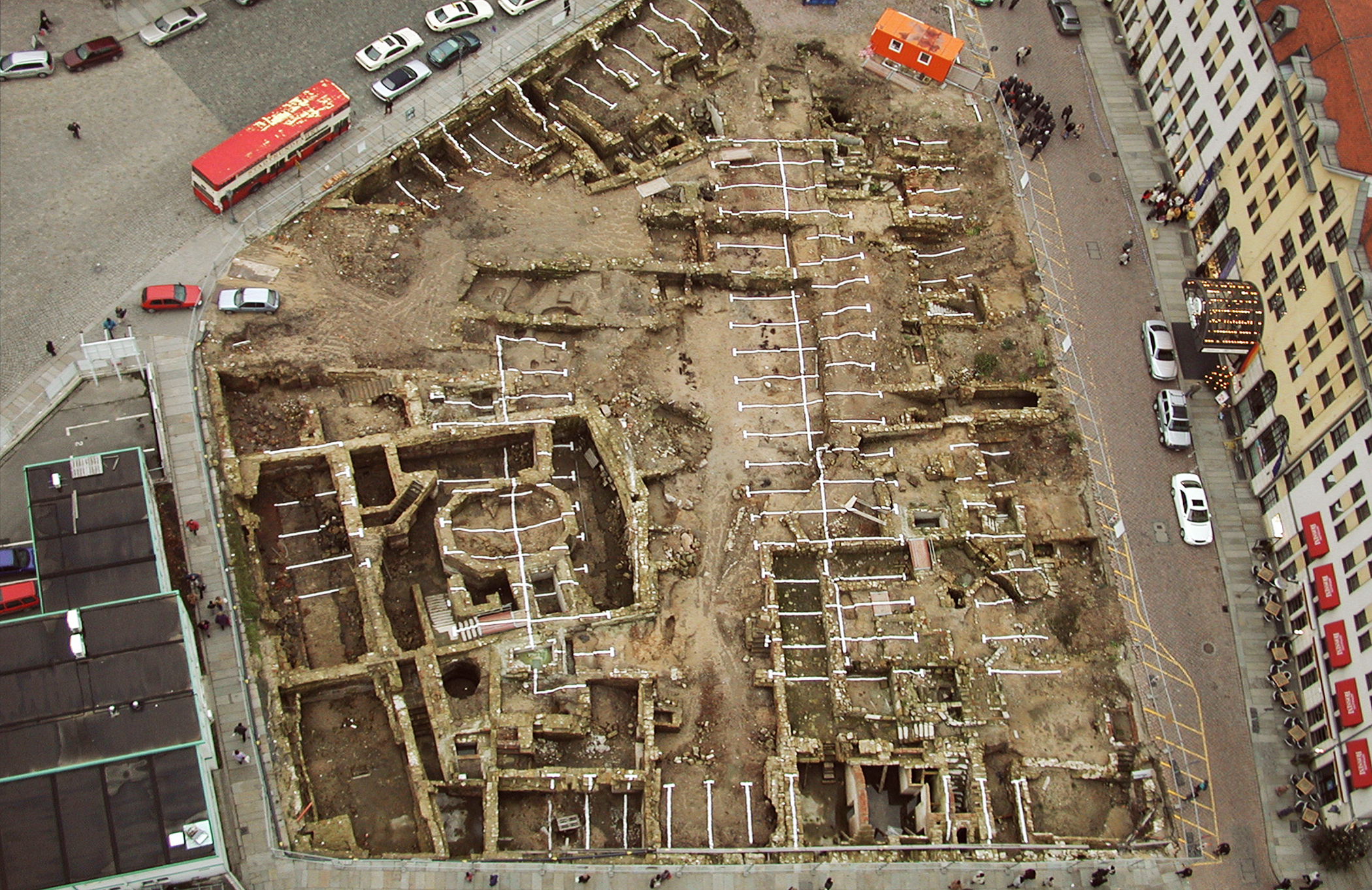
Reconstructed car park marking lines applied by hand with white lime, dimensions 45m x 110m,
archaeological excavation, historic city centre Dresden, Germany, 2002
HISTORICAL LAYERS is dedicated to the patterns and congruences of archaeological layers and building structures. In the historically oldest area of the city of Dresden, archaeological excavations revealed formal overlaps between the historical buildings, exposed settlement traces and the most recent usage layer, a parking lot. All archaeological findings showed an almost congruent correspondence in location, form and structure and were also within the grid of the parking lot markings. In order to check the construction-historically and archaeologically inconclusive matches and to prove these congruences, the parking lot markings were reconstructed with centimetre precision. Jahna Dahms reapplied the marking lines by hand directly with lime paint on the archaeological excavation area. The site-specific intervention was realized as a drawing with white lime paint in the dimensions of 45m x 110m on the wall foundations and archaeological ground findings.

DAS GEHEIMNIS DER HISTORISCHEN SCHICHTEN
Ausgangspunkt dieser Arbeit war eine Reflexion über die archäologische Annahme, dass sich im Zentrum Dresdens lange vor der Stadtgründung ein alter Siedlungsplatz mit einer bronzezeitlichen Kultstätte befand. Dort im Stadtzentrum, direkt neben der berühmten Frauenkirche, soll die erste Kirche Dresdens gebaut worden sein. In der konzeptionellen und künstlerischen Auseinandersetzung mit dem Ort entwickelte Jahna Dahms die Hypothese von PARKPLATZ, dass er der historische und vielleicht auch geistige Ausgangspunkt einer Besiedlung in diesem Gebiet sein könnte. Aus diesem Grund führte sie eine Bestandsaufnahme des Gebietes durch. In der Mitte des Dorfes befand sich ein alter Parkplatz mit recht ungewöhnlichen Schildern. Die genaue Vermessung dieses Parkplatzes ergab, dass die Markierungslinien, völlig untypisch, nicht den deutschen Standardgrößen von Parkplätzen entsprachen. 2001/2002 ergab die erste archäologische Ausgrabung an diesem Ort die sukzessive bauliche Nutzung des Ortes. Die Annahmen der ältesten Kirche und der bronzezeitlichen Siedlung konnten archäologisch bestätigt werden. Jahna Dahms dokumentierte die Ausgrabung im Rahmen einer Projektzusammenarbeit mit dem Sächsischen Landesamt für Archäologie. Dabei entstand für sie der Eindruck, dass die freigelegten Mauerkronen fast aller Überreste aus verschiedenen Jahrhunderten und auch die Struktur des entdeckten bronzezeitlichen Gräberfeldes mit den ursprünglichen Markierungslinien des darüber liegenden Parkplatzes übereinstimmten. Testmessungen verdichteten die Vermutung, dass die archäologischen Schichten mit dem Parkplatz des 20. Jahrhunderts identisch sind. Um diese weitere Hypothese zu überprüfen, ermöglichten das Sächsische Landesamt für Archäologie und der Investor Herr Arturo Prisco die Durchführung einer künstlerischen Arbeit direkt auf der Ausgrabungsstätte. In sehr arbeitsintensiven Monaten wurden die Markierungslinien des Parkplatzes exakt auf dem Gelände rekonstruiert und mit einer speziellen Kalkfarbe auf der Ausgrabungsfläche neu aufgetragen. Jahna Dahms schuf über das gesamte Areal eine großformatige Zeichnung, die die Bodenstruktur der archäologischen Ausgrabung und auch die großen Höhenunterschiede der Mauerkronen überwindet. Mit dieser Arbeit konnten sie die enorme Übereinstimmung der räumlichen Anordnung des Ortes in Rhythmus, Anordnung und Größe mit der Anlage des Parkplatzes nachweisen, die sich in den verschiedenen Jahrhunderten immer wieder wiederholte. Von einer höheren Erhebung aus zeigte sich das erstaunliche Phänomen der formalen und ideellen Übereinstimmung verschiedener historischer Schichten im Grundriss des Ortes. Die großformatige Zeichnung PARKPLATZ – DAS GEHEIMNIS DER GESCHICHTLICHEN SCHICHTEN über dem gesamten Ausgrabungsgelände beschrieb den genius loci, die räumlichen und immateriellen Faktoren, die den Geist eines Ortes bestimmen, und enthüllte seine zerbrechliche Schönheit.
THE SECRET OF HISTORICAL LAYERS
The starting point of this work was a reflection on the archaeological assumption that an old settlement site with a Bronze Age cult site was to be found in the centre of Dresden long before the city was founded. There in the city centre, right next to the famous Frauenkirche, the first church of Dresden is said to have been built. In the conceptual and artistic examination of the place, Jahna Dahms developed the hypothesis PARKPLATZ – THE SECRET OF HISTORICAL LAYERS, that it could be the historical and perhaps also spiritual starting point of a settlement in this area. For this reason, she carried out a survey of the area. In the centre of the village there was an old car park with quite unusual signs. The exact measurement of this parking lot revealed that the marking lines, completely untypical, did not correspond to the German standard sizes of parking lots.The first archaeological excavation at this site in 2001/2002 revealed the successive structural uses of the site. The assumptions of the oldest church and the Bronze Age settlement could be confirmed archaeologically. Jahna Dahms documented the excavation in the context of a project collaboration with the State Office for Archaeology of Saxony. The impression arose for them that the exposed wall crowns of almost all remnants of various centuries and also the structure of the discovered cemetery of the Bronze Age coincided with the original marking lines of the parking lot above. Test measurements condensed the assumption that the archaeological strata were identical to the 20th century parking lot. In order to test this further hypothesis, the State Office for Archaeology of Saxony and the investor Mr. Arturo Prisco made it possible to carry out an artistic work directly on the excavation site. In very labour-intensive months, the marking lines of the car park were reconstructed exactly on the site and reapplied with a special lime paint on the excavation area. Jahna Dahms created a large-scale drawing over the entire area, which overcame the soil structure of the archaeological excavation and also the great differences in height of the wall crowns. With this work, they were able to prove the enormous concordance of the spatial arrangement of the place in rhythm, arrangement and size with the layout of the parking lot, which was repeated over and over again in the various centuries. From a higher elevation, the amazing phenomenon of formal and idealistic congruence of different historical layers in the ground plan of the place became apparent. The large-format drawing PARKPLATZ – THE SECRET OF HISTORICAL LAYERS over the entire excavation area described the genius loci, the spatial and immaterial factors that define the spirit of a place and revealed its fragile beauty.

PARKPLATZ HISTORICAL LAYERS Site-specific Drawing
Reconstructed car park marking lines applied by hand with white lime, dimensions 45m x 110m,
archaeological excavation, historic city centre Dresden, Germany, 2002
PARKPLATZ HISTORICAL LAYERS Site-specific Drawing
Reconstructed car park marking lines applied by hand with white lime, dimensions 45m x 110m,
archaeological excavation, historic city centre Dresden, Germany, 2002